Marathon sits in the middle of the Florida Keys, where the island chain bends west and the water on both sides turns into a patchwork of sand, turtle grass and hard bottom. The Seven Mile Bridge runs off its western end, and the flats on either side of that bridge are some of the most paddled and poled shallow water in the United States. This guide explains what the bottom looks like, roughly how deep each zone runs, where to launch, and when to go. For the current picture, open the satellite depth map (updated regularly) for this cell.
What the bottom looks like
The Marathon area has two very different sides.
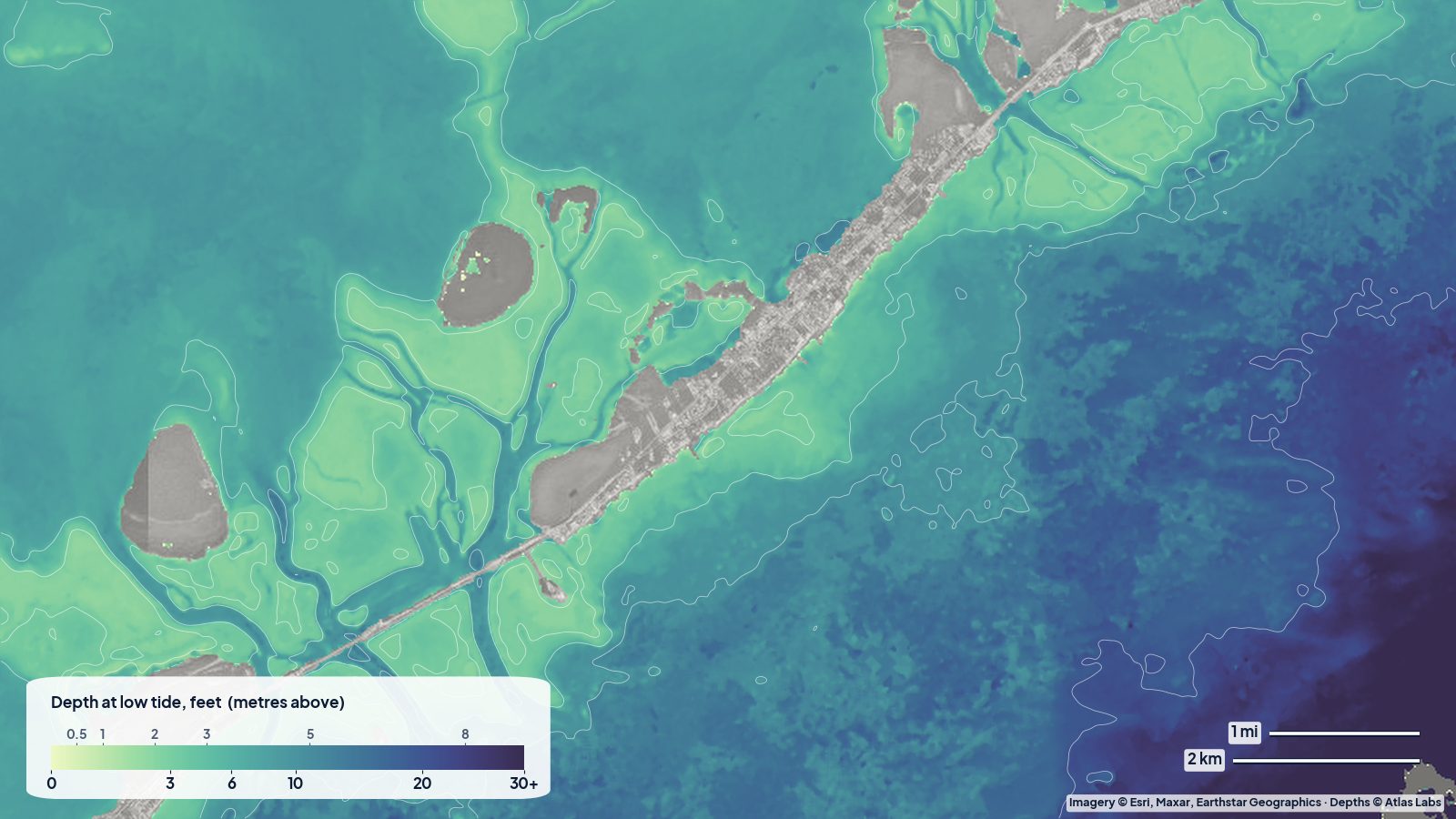
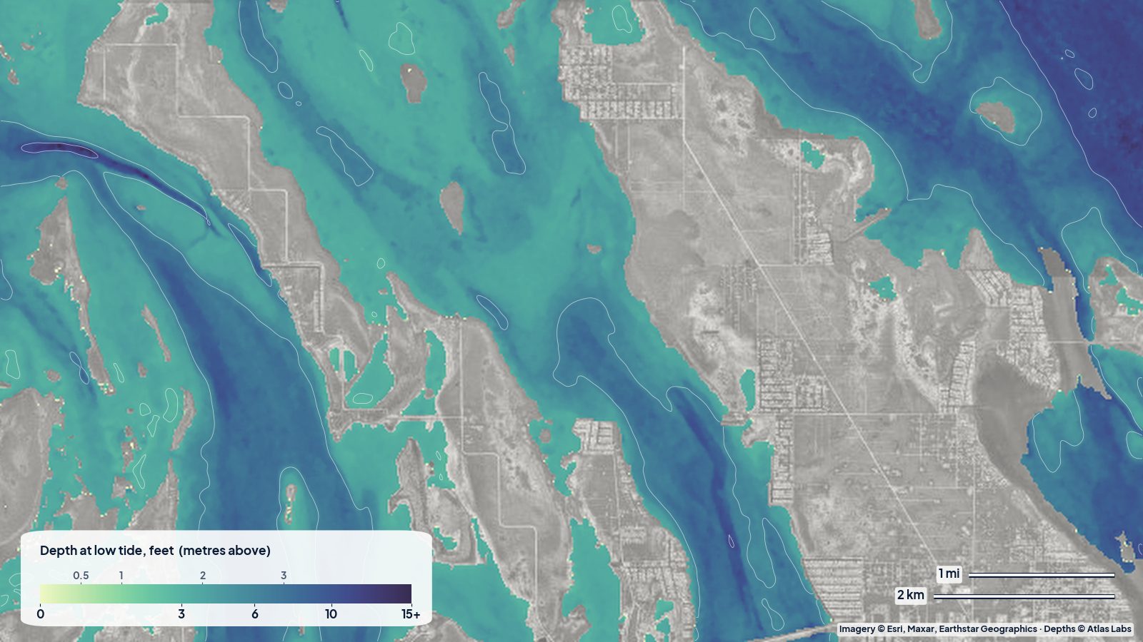
Gulf (bayside) of Marathon is a wide, shallow shelf of turtle grass and sand that stretches north toward Florida Bay. The bottom is mostly soft to firm sand with grass beds, broken by small mangrove islands and a few natural channels. Water clarity swings with the wind: calm mornings are gin clear, a stiff north-easterly turns everything milky.
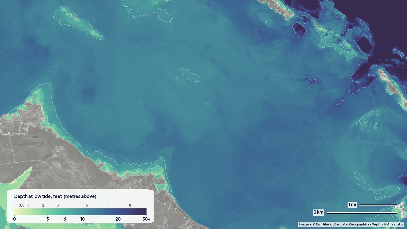
Ocean (Atlantic) side drops faster. Close to shore you have sand and grass, then patch reefs and hard bottom, then Hawk Channel, the natural passage inside the reef line. Beyond that is the barrier reef with Sombrero Reef as the local landmark.
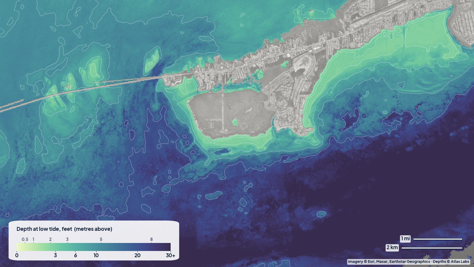
Around the Seven Mile Bridge the tide pushes hard through the bridge spans and over the surrounding flats. The old bridge pilings create current seams and holes; the flats next to them are grass and sand with scattered rock.
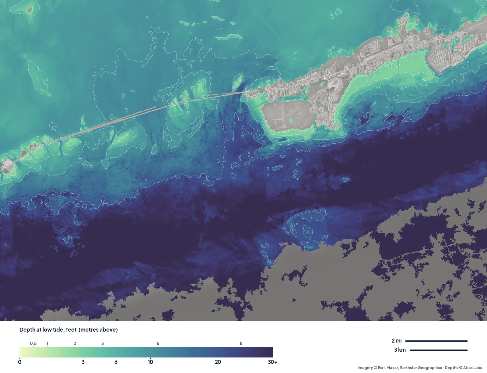
The real depth map of Marathon and the Seven Mile Bridge at low tide. Pale green is the shallow sand and grass along both shores and around Boot Key; the blues off the oceanside step down toward Hawk Channel and the reef. Tap any spot on the live map for a number.
Approximate depth by zone
These are typical ranges, not surveyed numbers. Depth changes with tide and the exact spot, so always check the live map before you go.
- Bayside grass flats north of Marathon: roughly 1 to 4 ft (0.3 to 1.2 m) at low tide, with large areas under 2 ft (0.6 m). Some banks go almost dry on a spring low.
- Natural channels and cuts through the bayside banks: roughly 4 to 8 ft (1.2 to 2.4 m).
- Boot Key Harbor: a protected mooring field, generally about 6 to 9 ft (1.8 to 2.7 m) in the main basin, shallower at the edges.
- Oceanside flats off Sombrero Beach and Boot Key: roughly 2 to 6 ft (0.6 to 1.8 m) close in, then patch reefs in 10 to 20 ft (3 to 6 m).
- Hawk Channel: published descriptions put it between about 9 and 34 ft (2.7 to 10 m) along its length; off Marathon expect mid-teens in feet.
- Flats beside the Seven Mile Bridge: roughly 1 to 5 ft (0.3 to 1.5 m) with deeper scour holes next to pilings.
Launch points and boat ramps
- Sombrero Beach (oceanside, Marathon): a sandy public beach with parking and an easy carry-in launch for kayaks and paddleboards. Flats and patch reef are a short paddle away.
- Curry Hammock State Park (just east of Marathon): a popular, low-cost kayak launch with a sheltered mangrove loop and clear shallow water, often called the best all-round paddling spot in the Keys.
- Keys Fisheries / 33rd Street area and Boot Key Harbor ramps: public and marina ramps for skiffs and small boats; expect fees and busy weekends.
- Bahia Honda and Little Duck Key (west end of the bridge): small ramps and beach launches that give direct access to the Seven Mile Bridge flats. See the Bahia Honda depth map for details.
Best tide, wind and season
- Tide: For sight fishing on the flats, the last of the falling tide and the first of the rising tide give the clearest water and concentrate fish on the edges. For paddling across the bayside banks, go on a rising tide so you are not left dragging over grass.
- Wind: The bayside is sheltered from easterlies and south-easterlies; the oceanside is sheltered from northerlies. On a 15 to 20 knot day, pick the lee side and stay close to the islands.
- Season: December to April is the peak for visitors and for calm, clear days between fronts. Summer is hot and glassy in the mornings with afternoon storms; it is also the busiest time under the bridge for boat traffic. Lobster mini-season (late July) and the regular season (August onward) bring heavy weekend traffic.
Hazards
- Strong current at the bridge: The Seven Mile Bridge spans funnel the tide. Paddlers should cross perpendicular to the flow and avoid the pilings on a running tide.
- Boat traffic: The bridge channel and Boot Key Harbor entrance are busy. Stay out of marked channels when you can and wear bright colours.
- Grounding on banks: Bayside banks go dry on low spring tides and the grass is protected. Running a skiff aground on seagrass leaves a prop scar that takes years to heal and can bring a fine.
- Hard bottom and coral heads: Oceanside patch reefs rise suddenly from 15 ft (4.5 m) to a few feet. Never anchor on coral.
- Sun and heat: There is almost no shade on the flats.
Kayak and skiff draft guidance
A kayak or paddleboard drawing 4 to 6 in (10 to 15 cm) can float over almost everything here except exposed banks at low tide. Paddling across a bank with 6 in (15 cm) of water over grass is slow and damages the bottom; use the channels shown on the map.
A technical poling skiff drawing 6 to 10 in (15 to 25 cm) can work most of the bayside flats on a mid tide. A bay boat drawing 12 to 18 in (30 to 45 cm) should stay in water the map shows as 3 ft (0.9 m) or more and treat anything shallower as a no-go on a falling tide. Add a margin of at least 1 ft (0.3 m) on top of your draft when the wind is pushing water out of the bay.
Frequently asked questions
How deep is the water under the Seven Mile Bridge?
It varies a lot. The marked channel near the old bridge is deep enough for larger boats, while the flats a few hundred feet to either side are often only 1 to 5 ft (0.3 to 1.5 m). Check the live map for the exact spot.
Can I kayak from Marathon to the Seven Mile Bridge?
Yes, from Sombrero Beach or the west end of Marathon it is a few miles of mostly shallow water. Pick a calm day, cross the bridge channel at right angles and watch the current.
Is Boot Key Harbor deep enough for a sailboat?
The mooring field generally holds about 6 to 9 ft (1.8 to 2.7 m), which suits most cruising monohulls. Confirm with the city marina before you arrive.
Where is the best snorkeling near Marathon?
Sombrero Reef, a few miles offshore, is the main attraction and needs a boat. From the beach, the patch reefs and grass off Sombrero Beach and Bahia Honda give easy shallow snorkeling.
Can a bay boat run the bayside flats north of Marathon?
Only in the channels on a rising tide. Most of the open banks are under 3 ft (0.9 m) and many are under 2 ft (0.6 m) at low water.
Related reading
- Bahia Honda depth map for kayaks and snorkelers
- Upper Keys backcountry depth map: Key Largo and Islamorada
- Florida Bay and Flamingo depth map
Safety note: ShoalScope depth maps are satellite estimates intended for planning and curiosity. They are not for navigation. Use official charts, local knowledge and your own eyes on the water, and always wear a life jacket.