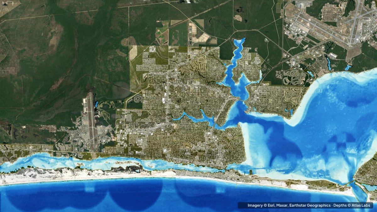
Crab Island is not an island. It is a broad, bright sandbar just inside Destin’s East Pass, on the north side of the Marler Bridge, where Choctawhatchee Bay meets the Gulf of Mexico. On a summer weekend it hosts hundreds of anchored boats, floating vendors and thousands of people standing in waist-deep water. It is also surrounded by a deep, fast channel and heavy traffic, which is why so many visitors ask the same question before they go: how deep is it, and where is it safe? This guide gives typical depths by zone, the launch options, tide and wind advice, and the hazards. The satellite depth map for this cell is updated regularly.
What the bottom looks like
- The sandbar: firm white quartz sand with clear emerald water, the classic Destin look. It covers a large area north of the bridge and shelves gradually, with the shallowest sand toward the middle and the north.
- East Pass channel: a dredged, jettied inlet with strong current, running south of the bridge between Destin harbour and Okaloosa Island. The channel curves around the sandbar on its east and south sides.
- Choctawhatchee Bay beyond the sandbar: a large brackish bay that is deeper and darker than the sandbar, with grass and sand bottom along its edges.
- Destin Harbor: a protected, dredged harbour full of charter boats, on the east side of the pass.
- Norriego Point: a sandy point at the harbour mouth with a sheltered swimming lagoon, popular with families and paddlers.
Approximate depth by zone
Typical ranges only. The sandbar shifts with storms and the water level changes with tide and wind, so check the live map on the day.
- Crab Island sandbar, main anchoring area: roughly 1 to 5 ft (0.3 to 1.5 m); most of it is waist deep at mid tide. Local guides describe 2 ft (0.6 m) or less in places at low tide and up to about 8 ft (2.4 m) at the deep edges on a high tide.
- Sandbar edges toward the channel: drop quickly to roughly 8 to 15 ft (2.4 to 4.6 m).
- East Pass channel: roughly 20 to 30 ft (6 to 9 m) in the dredged cut, with currents reported at several knots at peak flow.
- Norriego Point lagoon: roughly 1 to 5 ft (0.3 to 1.5 m), sheltered.
- Choctawhatchee Bay near the bridge: roughly 6 to 15 ft (1.8 to 4.6 m), deeper in the middle of the bay.
- Gulf beach south of the pass: roughly 3 to 10 ft (0.9 to 3 m) in the first hundred yards, with a sandbar and trough.
Launch points and boat ramps
- Destin City boat ramp (Joe’s Bayou / Clement Taylor Park area): public ramps on the bay side of Destin, a short run to the sandbar.
- Okaloosa Island ramps and parks (Fort Walton Beach side): public access on the west side of the pass; paddlers often launch here and cross under the bridge.
- Norriego Point: a park with parking where paddleboards and kayaks can launch into the sheltered lagoon and paddle a few hundred yards to the sandbar edge.
- Rentals and shuttles in Destin Harbor: pontoon, jet-ski and paddleboard rentals and water taxis run to Crab Island all summer; for most visitors this is the easy way out.
Best tide, wind and season
- Tide: Visit near high tide if you want to float and swim, and near low tide if you want to stand and walk. The tide range is small, roughly 1 to 2 ft (0.3 to 0.6 m), but it moves a lot of water through the pass, so slack tide is the safest time for paddlers to cross.
- Wind: A south or south-west sea breeze builds chop on the bay side of the bridge in the afternoon; mornings are calmer. The sandbar itself is shallow enough to stay comfortable in moderate wind.
- Season: May to August is the party season, with the biggest crowds on Memorial Day, July 4th and Labor Day weekends. Spring and fall are quieter with pleasant water. Winter is empty and cold.
Hazards
- Channel current: The East Pass runs hard. Swimmers and paddlers have been swept off the sandbar edge into the channel. Stay on the bar and keep children away from the drop-off.
- Boat traffic: The pass and the approach to the sandbar are among the busiest waters in the Panhandle in summer. Propellers and swimmers share the same water.
- Drop-offs: The sandbar edge goes from waist deep to over your head within a few steps.
- Alcohol and heat: The combination with moving water and traffic is the main cause of incidents here.
- Marine life: Stingrays rest in the sand; shuffle your feet.
Kayak and skiff draft guidance
Kayaks and paddleboards (4 to 6 in, 10 to 15 cm of draft) can reach the sandbar from Norriego Point or Okaloosa Island with a short paddle, but only at or near slack tide and never through the middle of the channel on a running tide. Stay close to the sandbar edge and out of the marked channel.
Pontoons, bay boats and centre consoles drawing 12 to 24 in (30 to 60 cm) anchor on the bar in 3 to 5 ft (0.9 to 1.5 m) of water. Approach slowly from the channel side, watch the depth drop, and set your anchor so the boat swings clear of neighbours. Deeper-draft boats should anchor at the edges in 5 to 8 ft (1.5 to 2.4 m).
Frequently asked questions
How deep is Crab Island?
Most of the sandbar is 1 to 5 ft (0.3 to 1.5 m) deep, waist deep at mid tide. The edges drop quickly into the East Pass channel, which is roughly 20 to 30 ft (6 to 9 m) deep.
Can you swim to Crab Island?
Not safely. The sandbar is separated from shore by the pass channel, which has strong current and heavy boat traffic. Use a boat, a paddleboard at slack tide, or a water taxi.
Is there a boat ramp near Crab Island?
Yes, Destin’s city ramps on the bay side and the Okaloosa Island ramps are both a short run away.
Can I paddleboard to Crab Island?
Yes, from Norriego Point or Okaloosa Island near slack tide, staying along the sandbar edge and out of the channel. It is not a beginner paddle on a running tide.
When is the best time to visit Crab Island?
Weekday mornings in late spring or early fall, near mid to high tide, for the clearest water and fewest boats.
Related reading
- Crystal River and Homosassa depth map
- Tampa Bay depth map: Fort De Soto and Weedon Island
- Christmas Bay, Galveston depth map
Safety note: ShoalScope depth maps are satellite estimates for planning only and are not for navigation. The East Pass channel is dangerous for swimmers and paddlers. Follow Coast Guard and local guidance, and wear a life jacket.